
TOPEKA, Kan. (WIBW) – Yesterday was very hot and breezy, this weekend will be very hot and windy. Heat indices for most in the upper 90s to around 105° with wind gusts 35-45 mph. The pattern changes for the work week with several chances for rain returning to the area with steady temperatures for most of the week.
Taking Action:
- Heat is the #1 concern through early next week: Today and Sunday will have heat indices in the upper 90s to as hot as 106°. Stay safe and follow heat safety protocol. With heat being the #1 weather related killer it has to be taken just as seriously as severe weather.
- While the high temperatures are hot, lows will remain warm as well. It’s just as important to be in a cool place at night as it is during the day so your body can recover from the day’s heat and to prepare for the next day’s heat.
- Next week’s weather pattern will have to be taken on a day by day basis with several disturbances pushing through. The first round of storms is expected Monday afternoon with the majority of the rain staying near north-central KS.
____________________________
Confidence on the weather pattern this weekend is high: Hot and windy for the next 2 days with gusts 40-45 mph during the day and 35-40 mph at night keeping temperatures warm. The overall pattern is for north-central KS to remain near 100° and for areas near I-35 to be relatively cooler and in the low 90s today and tomorrow.
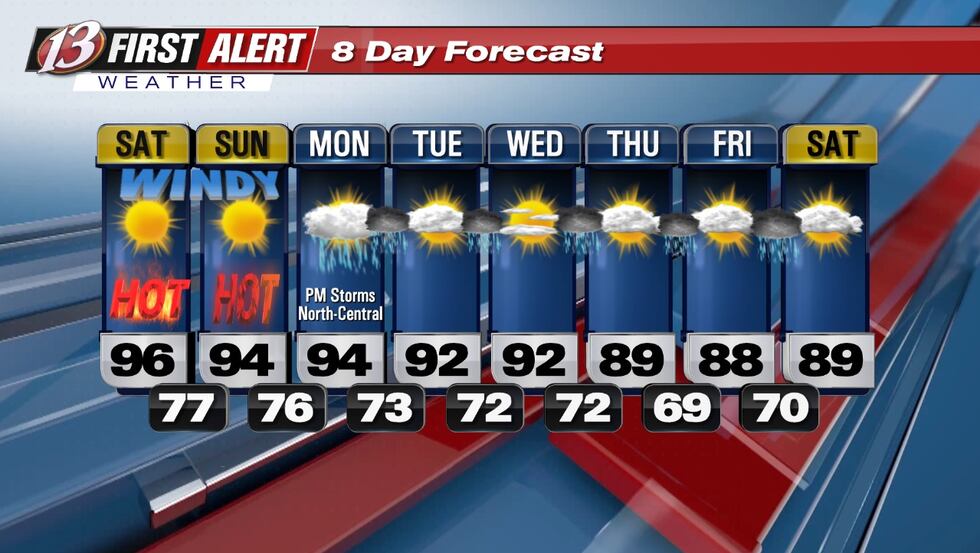
Today: Sunny. Highs in the mid-upper 90s. Winds S 20-30, gusts around 45 mph.
Tonight: Clear. Lows in the mid 70s to around 80°. Winds S 15-25, gusts around 35 mph.
Tomorrow: Sunny. Highs in the mid 90s. Winds S 20-25, gusts around 40 mph.
On and off storms next work week will mainly be at night so you don’t need to cancel outdoor plans although as always timing can change as we get closer to next week so keep checking back daily. This weather pattern is from a stalled frontal boundary will will keep the heaviest rain up in Nebraska and Iowa and while models have been consistent the last few days there still remains time for the storm system to shift (either north or south) and change our forecast. As of now lightning and possible flooding would be the only concerns with the other severe weather hazards very low to none but another detail that could change as we get into next week.
Copyright 2025 WIBW. All rights reserved.